How can the geography and themes of North America be adapted for use in a family-friendly Nintendo Pokémon game, where North America as such does not exist? Maps and details available under a CC-BY-SA License.
Published
Table of contents:
Introduction
Aside 1: The game maps of Pokémon.
Considerations of a Pokémon region
Mapmaking
A detailed map of the Noram Region
Factions
Game mechanics
Plot hooks
If you’d like to use this
Resources consulted
Introduction
Pokémon Sword is set in the Galar Region, the geography of which is based on modified map of the island of Great Britain. After playing this game, I started wondering how the Pokémon regions matched up to real-world locations, and spent a lot of time reading Bulbagarden’s writings on the topic.
I wanted to make my own region, loosely based on North America.
Goals of this project:
Create a map loosely based on North America, with a variety of regions, locations, gyms, and plot hooks
These maps can be divided into the following categories:
Subway maps
Generation I Kanto: routes, city markers, terrain type
Generation II Johto: routes, city markers, terrain type
Generation III Hoenn: routes, city markers, plus topographic map
Generation III Sevii Islands: city markers, routes, plus topographic map
Generation III Kanto: routes, city markers, plus topographic map
Generation IV Sinnoh: routes, city markers, plus topographic map
Generation IV Sinnoh Berry Searcher: routes, city markers, no terrain
Generation IV Johto: routes, city markers, plus topographic map and clip-art terrain
Generation VI Kalos: city markers, stylized routes, and topographic map
Generation VII Kanto: routes plus clip-art terrain type
Generation VIII Sinnoh: routes, city markers, and clip-art terrain
Satellite maps
Generation V Unova: city markers, routes, and pixel-art satellite imagery
Generation VII Alola: pure satellite imagery
Theme-Park maps
Generation VIII Galar: route and train connections, notable buildings, terrain types
Considerations of a Pokémon region
There’s a lot of things that go into a region’s design:
The trainer must have a home town.
The Pokémon professor must have a lab.
There must be 8 gyms, each gym with its own town.
There must be tunnels, surfing and fishing areas.
Progress must be gated, either by game mechanics such as the player not having access to a specific move or item, or through the simple expedient of the path being blocked.
There should be a logical progression through the world, with a clearly-defined goal for the player to reach. In Sword and Shield, this is accomplished via the bottom-to-top progression through the map.
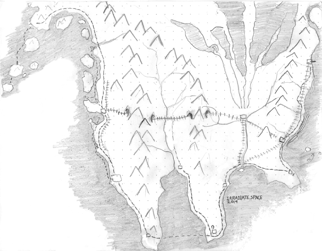
As of this writing, I have a hand-drawn map image that accounts for most of those items, but doesn’t align exactly with a map of North America.
This region is based on a distorted North America: The Aleutians and the Alaskan panhandle are enlarged; the West Coast is abridged. Baja California thickens, the Central Valley of California continues into the Gulf of California, and Mexico shrinks into Texas. Mountain ranges are simplified. The Great Plains lessen in width, and the Great Lakes are replaced with large glaciers feeding six rivers into one town in the middle of the plains. Florida shortens and becomes the base of a major East-Coast road leading up to Boston-ish. A number of railroads and routes are described.
Mapmaking
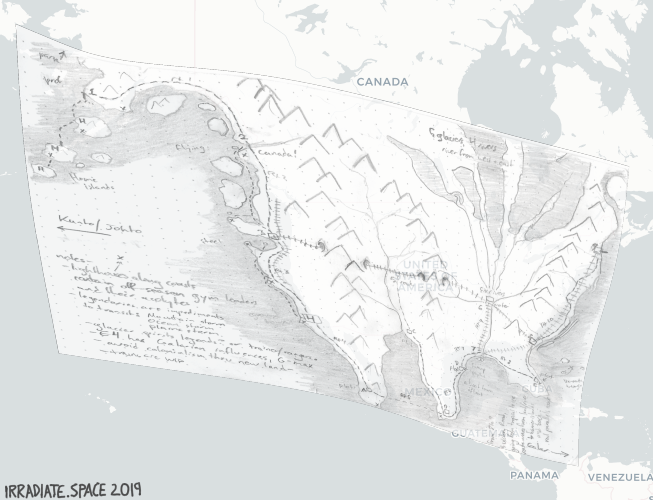
It’s possible to warp the above map to more-directly fit North America, like I’ve done in the following Web Mercator map:
The hand-drawn map is distorted and stretched to sit atop a map in the Web Mercator projection, using a base map tile set by CartoDB and data from the OpenStreetMap contributors.
How I transformed the image to match a Mercator map
#!/usr/bin/env bash
# Depends on gdal2tiles.py being in the local path
# https://gdal.org/programs/gdal2tiles.html
#

echo "Cleaning up workspace..."
rm ./3072x3072-trans_autogen.gtiff
# the problem here is that I have latlong, but need to express the latlong in easting-northing UTM coordinates
# using http://www.rcn.montana.edu/resources/converter.aspx
# -gcp 633.653  823.346  #1 Anchorage, -160 60
# -gcp 1457.6   2287.63  #2 Baja California, -110 23
# -gcp 2462.06  1825.77  #4 Florida, -80 25
# -gcp 2569.96  1095.64  #3 Boston -70 43
#
# Commenting this out because -s_srs not allowed?
# gdal_translate -of GTiff --s_srs "EPSG:4326" -a_srs "EPSG:3857" \

echo ""
echo "Commencing gdal_translate"
gdal_translate -of GTiff -a_srs "EPSG:4326" \
	-gcp  633.653  823.346  -160 60 `# Anchorage: Home Town` \
	-gcp  467.0   1251.0    -168 53 `# Aleutians: Home Island` \
	-gcp 1086.6   1029.63   -132 54 `# Juneau: Canada` \
	-gcp 1457.6   2287.63   -110 23 `# Ground Gym: Baja California` \
	-gcp 2462.06  1825.77    -80 25 `# Rocket Launch: Atlanta/Florida` \
	-gcp 2569.96  1095.64    -70 43 `# Galarian Town: Boston` \
	"3072x3072-trans.png" "./temp.gtiff"

echo ""
echo "Commencing gdalwarp"
gdalwarp -s_srs "EPSG:4326" -t_srs "EPSG:3857" -r cubicspline -tps -co COMPRESS=NONE -dstalpha -of GTiff "./temp.gtiff" "3072x3072-trans_autogen.gtiff"

echo ""
echo "Commencing gdal2tiles"
gdal2tiles.py --verbose -p mercator -s "EPSG:3857" -z 1-3 -w leaflet --tmscompatible -t "Noram Pokémon Region" -c "Made in 2019 by Ontploffing Boer" 3072x3072-trans_autogen.gtiff tiles/

echo ""
echo "Cleaning up temporary files ..."
rm ./temp.gtiff
echo "Done."
I don’t like this specific iteration of the map, for the following reasons:
Alaska is of a higher latitude than the rest of the continent, leading to distortion in shape and distances on the Mercator map. It’s displayed higher in the image, which is not great for a map.
As a result of point 1, the map dedicates a lot of space to areas that aren’t important to the story, like vast regions of Canada and the northern Great Plains.
So I would need to do one of:
re-project the web map in something other than Web Mercator
avoid the idea of having the web map’s lat-long coordinates match 1:1 to North American cities
And it would still an open question of whether I want the web map to be based on the hand-drawn map or on a digitization thereof.
I attempted to reproject this map in the web browser via OpenLayers and did not meet with success. Something doesn’t work in the OpenLayers configuration for warping the image and OpenStreetMap to a different projection. Also, the best map (the Dymaxion projection) isn’t supported by proj4 anyways, so I can’t warp the images into the preferred projection even if I got OpenLayers to work in the browser, or if I felt like reprojecting the original map again. Or if I felt like building the routes and cities as vector objects on a vector-tile map.
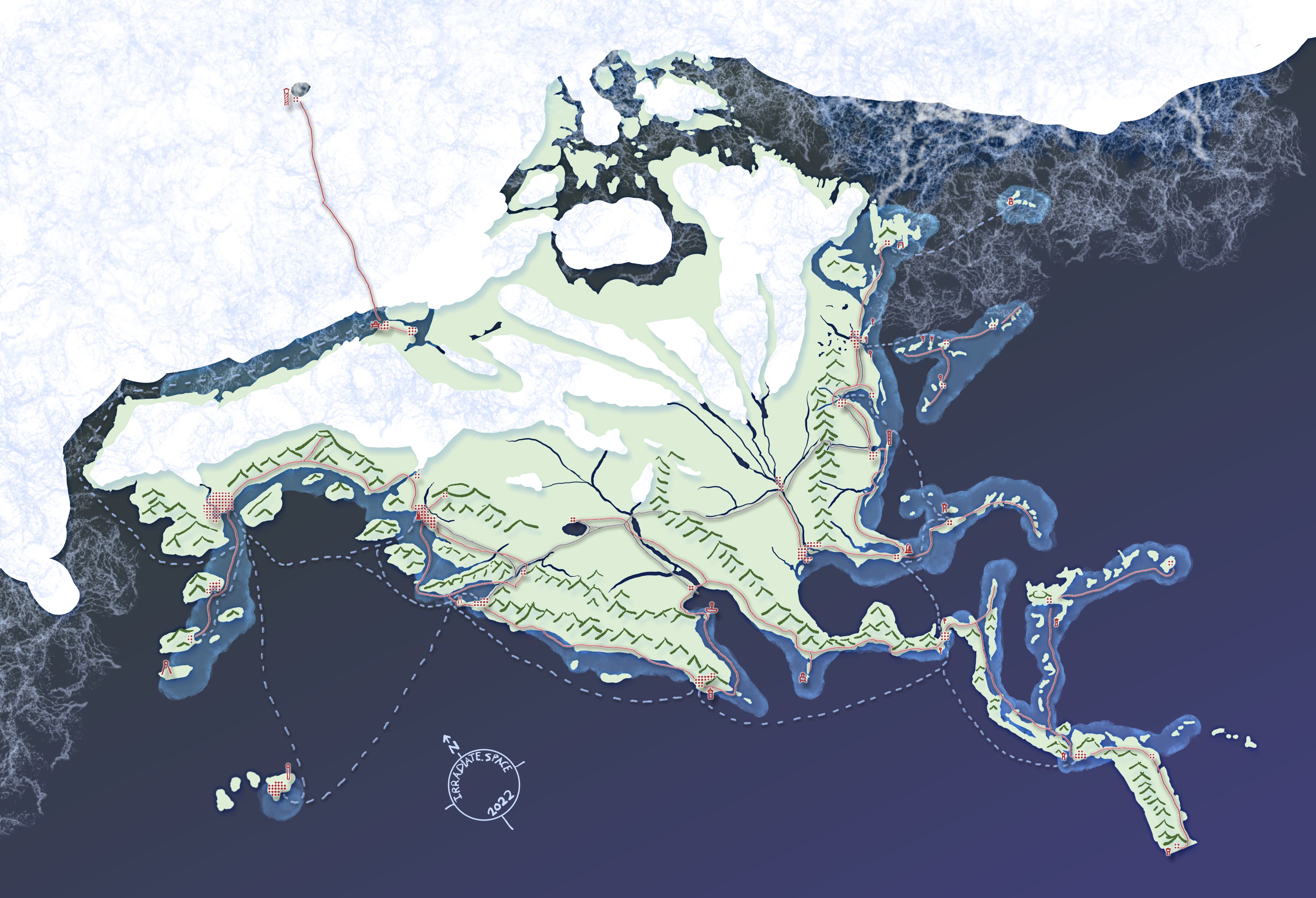
Instead, I’ll give you this raster attempt at what a subway map of Noram might look like, overlaid with trails and such. Maybe it’s too detailed.
A detailed map of the Noram Region
A pannable, zoom-able map of the Noram Region. As a young trainer, you'd start on your home islands in the west, and travel south and east around the continent, ending up in the northeast.
Where game locations are inspired by real-life locations, the location name shares the bubble with the real-life location. Click the bubble for a description of the town, with some plot hints? The size of a dot cluster for a settlement indicates its size.
Lighthouses (and the occasional other tall light) are marked on the map as well. Lighthouses have different shapes in different areas. A circle atop a straight stick is an automated lighthouse, without attendants.
Red lines are routes; sometimes they run across water. Grey lines are rail lines, which have stations at settlements, and many tunnels and bridges. Blue dashed lines are ship routes that the player can hitch rides on. Noram is a region where ship traffic is important to commerce, and thus somewhat important to the plot. The lighter-colored areas of ocean are surfable in places; beware icebergs in the north. Sometimes, they're Pokémon!
Factions
Alolan Portal Transit: They run the Solgaleo/Lunala/Ultra Beast transportation run, and try to breed new Cosmogs. But that’s basically it; they exist to keep the Warp Ride Pokémon happy.
Devon Corporation Extractive Resources Group (ERG): Here to extract the resources of this parallel Earth for the folks back home. A real folksy group, but big into heavy machinery and less-concerned about the side effects of mining.
Liberté du Pokémon: Kalosian extremists who want to kick humans out of Noram, leaving this new planet as a place only for Pokémon.
The Pokémon Grad Students Association: They’re here to do research, and they don’t have a lot of money, and fieldwork is boring. There’s usually a hobbyist somewhere who is willing to heal your Pokémon or carve you an Apricorn Ball.
Pokémon Friends Association: Why do we need a name? We just want to live peacefully with our Pokémon in a world that’s not polluted or barren.
Officers Jenny: SilphCo’s friendly Officers Jenny are here to enforce the law.
???: Were humans in Noram before the Alolan portal opened?
The Dockage Daily News: They’ll pay you for photos you take along the way, and sometimes give you tips of things to investigate. That’s right: you’re a citizen photojournalist in this game!
The New Kalos Times: Very pro-business paper.
Game mechanics
There are eight Pokémon Gyms spread across the towns and cities of Noram, but there are sixteen Pokémon types. Where are the other types’ Gym Leaders? They’re off training, of course! On a seasonal cycle, Gym leaders go off into the world to train. For most, that involves going off to tend a Lighthouse and develop their bonds with their Pokémon through a peaceful, day-to-day life. You can challenge these Gym leaders at their Lighthouses, or you can wait for them to come back to town to visit the Gym. Though that might take several in-game months.
Move keys and passes from the Key Items inventory to a Keychain, and put your Trainer ID on the keychain just like your housekey, the key to the spooky warehouse, the key to the abandoned warehouse, the rewards card for the Route 13 Pokémart, the Pizza Palace Rewards Card, and the Gym Badge Keychains. Have separate keychains for each service within the Poké Ride service, which are presented to the player, and which are presented by the trainer to Ride Pokémon when they are summoned.
Hidden Machine moves exist in these games and have the same purpose as the Poké Ride service. Why? “Well, why not? They’re useful to have,” says your grandfather as he hands you HM03 Surf.
Whirlpools: not found in open oceans, but in rivers and around ports and tidal flats.
Surfing in shipping lanes: Dodge big slow-moving ships to avoid getting knocked to shore, or ride their wakes carefully for a speed boost and to clear breakwaters.
Fog is a risk along the oceans; Defog is essential if the lighthouses are disabled for whatever reason. But if you don’t have Defog and the lighthouses are running, the lighthouse’s light shows above the fog to guide you.
Rocky walls are common in Noram’s mountains and cliffs; climb them with the Rock Climb move.
Trainer is given HM02 Fly by a grad student after the Poké Ride service crashes.
Containerized Pokémon centers have been dropped in random places by cargo blimps; many small towns were built around them. There are no Nurse Joys, even as robots: why would you need a nurse when you can feed your Pokémon into the healing machine yourself? There’s usually one of these near every lighthouse.
Kalosian-influence areas in eastern Noram don’t have containers, though. They have actual Pokémon centers in the Kalosian style.
The Pokéball Storage System, with easy access from the player’s Pokédex’s PC Remote Access feature, allows Trainers to swap Pokémon out at will, as long as they’re near enough to a Pokémon Center Container or another PC. There are parts of the world where you’ll be too far away to get access.
Jobs: Rather than hiring out your Pokémon to do jobs in random places to be “helpful”, as was done in Galar, the player can earn money by actually doing things with their Pokémon. It’s about the bond with the trainer, not about the Pokémon’s abilities on its own. Some of these jobs will be plot-relevant, like the Ranger Missions in the Pokémon Ranger games.
Planting: Plant seeds according to the ecological plan to receive money, or chop down plants according to the ecological plan to receive money. Or you can plant the wrong seeds, and for a while there’ll be unusual Pokémon nearby, but eventually another person will come along to correct the problem.
Errands: Fetch missions or escort quests, basically, but rather than doing this for the good of your soul, young trainers will do this for money and experience.
Photography: The player can be hired to goo get photographs of specific locations, to help people locate things or plan routes. This is still a developing continent, after all.
Seasons: Let’s say that in-game seasons progress at the rate of four in-game days per system day, or at about one quarter year in-game per week and half-day by the system clock. If gated correctly, you can make the ferry run up to Rakecoal Bay be limited to not-winter, and if the player chooses to trek from Rakecoal Bay Light to North Hole in the winter, they’ll get hit with Hail on top of all the Ice-type Pokémon on the ice cap instead of snow or Diamond dust.
Trains: Long-distance train tracks are just now being installed in Noram. The player can be hired to survey routes (visit them, maybe take some pictures) or clear away troublesome Pokémon.
A big storm on the west coast of Noram took out the road just south of Oceanwash City, so you’ll have to help the train crews build the tunnel to Endorheic Lake this week.
Lighthouses: Find off-season Gym Leaders in residence at at some lighthouses. Follow the beam of light at night to get to shelter! But why are there so many automated lights on eastern Noram? Is it just from a lack of Gym Leaders to watch over them?
Door colors: Color the doors of buildings according to their public use, so that people can tell whether a door is for a hospital (red), store (blue), generally-accessible building such as a business or open house (green), is locked but openable (black), or inaccessible (brown or grey).
Plot hooks
Key tension: Is Noram just for resource extraction? Leave Noram as a preserve for (non-native) Pokémon? A new place where people and Pokémon can live together?
It’s a barren world, right? Where do Pokémon come from? Where do legendary Pokémon come from? Would something like large-scale resource extraction or digging a new Panama Canal aggravate or promote the formation of a new legendary?
How will Pokémon react to plans to the LdP’s plans to destroy human habitation?
How long have humans really been in Noram? Why do the towns on the east coast have a Kalosian feel, and why do they feel like they’re decades older than the towns on the west coast?
What’s up with the Gate to the East, and the stories of Houndooms greeting the first explorers on the Houndoom Islands? How could they have been there before explorers from Alola first set foot on the land?
The islands in the Eastern Ocean:
Why is there a golf course and who is the Director after whom Port Director was named? (Team Badguy did it!)
An empty but inhabited island? (Team Badguy’s Secret Base, where everyone’s hiding because you showed up!)
Strange noises in the Flying-Type Sanctuary? (Team Badguy have their own rocket launch site!)
Who really controls the Officers Jenny? (SilphCo thought they did, but now it’s Team Badguy!)
What happens if someone hacks or DDOSes the ride-hailing app? How will you get around? What is the ludonarrative value of being gifted with a Pokémon who knows Surf by your grandmother, HM01 Cut by your grandfather, and a Poké Ride hailer by your parents?
What happens if someone hacks the Pokémon Center Containers? How will you heal your Pokémon? How will you access the Pokémon Storage System? (Better have a balanced party…)
Are Officers Jenny human? Will Pokémon attack them? What ‘attacks’ might a corrupted robot police officer use?
Attacks: Spark, Tackle, Smog, Mist, Constrict, Screech, Light Barrier and other things analogous to nonlethal weaponry and nonlethal police tactics.
Type: Electric/Steel
Variations: Officer Jenny, Damaged Jenny (low speed, defensive and stat-weakening moves), Destroyed Jenny (low HP, Struggle, basically just blocks the fastest path)
If you’d like to use this
Well, first consult Nintendo, because they own Pokémon and I’m sure that they’d like to have a word with you. I can’t give you the rights for their stuff.
In short: as far as the bits of this work that are original to me are concerned: Yes, you may use this in your worldbuilding, fanfic, fangame, and so on. It doesn’t even have to be for Pokémon; you could use this setting for Digimon or something without pocket monsters. You are free to copy and redistribute this material in any medium or format, and to adapt, remix, transform, and build upon the material, under these conditions:
You can’t apply legal terms or technological measures that legally restrict others from doing anything permitted by the license.
If you’d like to use this work for commercial purposes, contact me. There’s some links in the footer of this site that will work, if you have a Mastodon account.


 License.